
Introduction
Modern surveying and mapping projects increasingly depend on digital technologies to collect, process, and interpret accurate geographical information. Traditional surveying methods remain important, but aerial photography, drone mapping, and photogrammetry have introduced new ways to capture large areas and convert visual information into measurable 3D models. These technologies are particularly useful in construction, land development, mining, infrastructure planning, and topographic documentation.
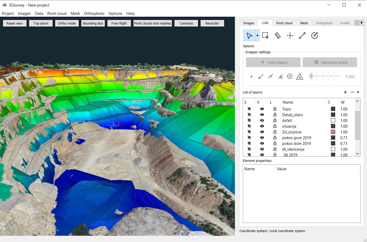
3Dsurvey 4.2.1 is a professional surveying and photogrammetry application designed to transform aerial images and survey data into detailed digital outputs. It provides tools for processing photographs, generating 3D representations, creating terrain models, and analyzing geographical information. By bringing several surveying-related tasks into one working environment, the software supports professionals who need to convert collected field data into practical mapping and engineering results.
What Is 3Dsurvey 4.2.1?
3Dsurvey is a specialized software solution developed for land surveying, photogrammetry, and 3D mapping workflows. It allows users to work with aerial photographs and other survey information to produce digital terrain models, point clouds, orthophotos, and 3D representations of real-world locations.
The application is particularly relevant to drone-based surveying projects. Images captured by drones can be processed through photogrammetry techniques to reconstruct surfaces and generate measurable geographical outputs.
Rather than treating photographs as ordinary visual files, 3Dsurvey uses image-processing and reconstruction workflows to extract spatial information. This makes it useful for professionals who require more detailed documentation of land, buildings, construction sites, and other physical environments.
Key Features of 3Dsurvey 4.2.1
1. Photogrammetry Processing
Photogrammetry is one of the central technologies used in 3Dsurvey. It involves analyzing overlapping photographs to identify common points and reconstruct the geometry of photographed objects or landscapes.
This functionality helps users convert aerial images into measurable digital information. It is especially useful for drone operators, surveyors, and mapping professionals working with large outdoor areas.
2. 3D Point Cloud Generation
Point clouds provide a digital representation of physical surfaces through collections of spatial coordinates. They are widely used in surveying, construction documentation, terrain analysis, and 3D reconstruction.
3Dsurvey supports point-cloud-based workflows that help users examine surface geometry and understand the spatial characteristics of surveyed locations.
3. Digital Terrain Modeling
Terrain models are important for understanding elevation changes, land shapes, and surface characteristics. They provide useful information for site preparation, construction planning, and geographical analysis.
The software supports terrain modeling workflows that help professionals represent surveyed landscapes in a digital format.
4. Orthophoto Creation
Orthophotos are geometrically corrected aerial images that provide a consistent scale across the represented area. Unlike ordinary aerial photographs, they are suitable for measurement and mapping applications.
3Dsurvey helps users generate orthophoto outputs from processed image data, making aerial information more practical for surveying and project documentation.
5. Drone Surveying Support
Drones have become valuable tools for collecting geographical data because they can capture aerial imagery across extensive areas in relatively short periods.
3Dsurvey is designed to support drone-based photogrammetry workflows, allowing users to process collected images and develop mapping outputs for different professional applications.
6. 3D Reconstruction
Three-dimensional reconstruction helps users understand the shape and structure of real-world environments. By processing suitable image datasets, the software can generate digital representations of surveyed objects, structures, and landscapes.
These outputs can support visualization, measurement, inspection, and technical documentation.
7. Survey Data Analysis
Surveying projects often involve multiple types of information, including coordinates, elevation measurements, imagery, and surface data. Organizing these elements is important for producing useful project results.
3Dsurvey provides a dedicated environment for working with surveying information and preparing outputs that can support further engineering and mapping activities.
How 3Dsurvey Works
The general workflow in 3Dsurvey involves collecting suitable image data, processing photographs, generating spatial information, and preparing the required surveying outputs.
A typical project can involve the following steps:
-
Data Collection: Capture aerial photographs using a drone or another suitable imaging platform.
-
Image Processing: Import the collected photographs and prepare them for photogrammetric processing.
-
3D Reconstruction: Process overlapping images to identify spatial relationships and reconstruct surveyed surfaces.
-
Model Generation: Generate relevant outputs such as point clouds, terrain models, and orthophotos.
-
Data Analysis: Review the generated information and examine geographical features, elevations, and surface details.
-
Exporting Results: Prepare suitable project outputs for documentation and further professional workflows.
This process helps transform raw image collections into structured geographical information.
Professional Applications of 3Dsurvey 4.2.1
3Dsurvey can be useful across several industries where accurate geographical information and 3D visualization are important.
Construction and Civil Engineering
Construction professionals can use photogrammetry and 3D mapping outputs to document project sites, examine terrain conditions, and support construction planning. Digital surface information can also assist with reviewing site progress.
Land Surveying
Land surveyors can benefit from digital mapping workflows that help document geographical areas and generate measurable representations of surveyed locations.
Mining and Quarry Management
Mining operations frequently require information about terrain conditions, excavation areas, and surface changes. Photogrammetric mapping can support site documentation and spatial analysis.
Agriculture and Land Management
Aerial mapping can help agricultural professionals understand field layouts, surface characteristics, and land conditions. Digital geographical information can also support broader land-management activities.
Infrastructure Projects
Road construction, infrastructure development, and other large-scale projects often require detailed geographical documentation. 3D mapping outputs can help project teams understand existing site conditions.
Benefits of Using 3Dsurvey 4.2.1
Using dedicated photogrammetry software can make surveying workflows more organized and improve the way collected information is processed.
Some important benefits include:
-
Integrated Surveying Workflow: Brings important photogrammetry and mapping activities into a specialized environment.
-
Detailed 3D Representation: Helps create digital representations of surveyed environments.
-
Improved Site Documentation: Supports the preparation of visual and spatial records.
-
Drone Mapping Capabilities: Makes aerial image processing useful for professional surveying projects.
-
Terrain Visualization: Helps users understand elevation differences and surface characteristics.
-
Practical Data Management: Supports organized processing of surveying information.
-
Multiple Professional Applications: Suitable for different mapping, engineering, construction, and land-management workflows.
The accuracy of generated results depends on image quality, camera calibration, ground control information, survey conditions, and processing settings.
Who Should Use 3Dsurvey?
3Dsurvey 4.2.1 is intended for users who regularly work with geographical data, aerial imagery, and 3D surveying applications.
It may be suitable for:
-
Professional land surveyors.
-
Photogrammetry specialists.
-
Drone mapping operators.
-
Civil and construction engineers.
-
Mining and quarry professionals.
-
GIS and mapping specialists.
-
Infrastructure planning teams.
-
Researchers working with spatial data.
Beginners interested in photogrammetry can also explore its workflows, although understanding basic surveying concepts can make the software easier to use.
System Requirements and Compatibility
Before installing 3Dsurvey 4.2.1, users should check the system requirements associated with this particular release.
Photogrammetry applications can process large image datasets and generate detailed 3D outputs, so hardware capability can influence overall performance.
A suitable workstation should generally have:
-
A compatible Windows operating system.
-
A modern multi-core processor.
-
Sufficient RAM for large image-processing projects.
-
Adequate SSD storage for project files.
-
A compatible graphics processor where required.
-
Updated graphics drivers.
Exact minimum and recommended specifications should be checked against the documentation for version 4.2.1 rather than assumed from newer releases.
Conclusion
3Dsurvey 4.2.1 is a specialized software solution for professional surveying, photogrammetry, drone mapping, and 3D reconstruction. Its focus on converting aerial photographs and survey information into useful digital outputs makes it relevant to several technical industries.
From point cloud generation and terrain modeling to orthophoto creation and geographical documentation, the software supports important stages of modern surveying workflows. It can be a useful option for surveyors, engineers, mapping specialists, and other professionals who work with spatial information and digital representations of real-world environments.
Our Paid Service
If you want to Purchase Cracked Version / KeyGen Activator /License Key
Contact Us on our Telegram ID :
Crack Software Policies & Rules:
Lifetime Activation, Unlimited PCs/Users,
You Can test through AnyDesk before Buying,
And When You Are Satisfied, Then Buy It.
 Sajeel Irfan